
Meet the team


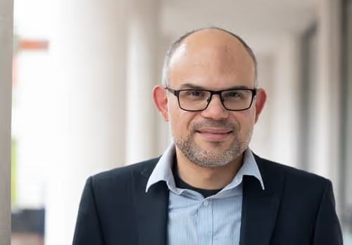
Joao Porto de Albuquerque
Professor João Porto de Albuquerque is Director of UBDC having joined the Urban Big Data Centre in October 2021 as Deputy Director. He is also a Professor in Urban Analytics at the School of Social and Political Sciences at the University of Glasgow.
João is a geographer and computer scientist with an interdisciplinary background. His research adopts a transdisciplinary approach to participatory urban analytics, intersecting digital geographies, geographic information science, urban data science, information management and development studies. His approach is underpinned by the investigation of new methods that bridge critical and geo-computational perspectives to include a plurality of voices in the generation, circulation, and usage of data, with the goal of enabling transformations to urban sustainability and climate resilience. His transdisciplinary research on socio-ecological-technical urban systems not only emphasises cross-border collaboration between the (environmental) sciences, social sciences, and humanities; it also goes beyond academic disciplines to engage in co-production and participatory research with non-academic societal/indigenous stakeholders.
João has been leading a research programme centred around the empowerment of vulnerable and deprived communities with citizen-generated data and participatory urban analytics to improve resilience to health and environmental risks. He has secured competitive research funds for his research in excess of £3.8m as PI (£13m as Co-I) from diverse national and international funding bodies (e.g. Global Challenges Research Fund, Leverhulme Trust, ESRC, EPSRC, Belmont Forum, NIHR, EU H2020, FAPESP, CAPES) in collaboration with academic and non-academic partners in several countries, including Australia, Brazil, Bangladesh, Colombia, Ghana, Germany, Kenya, Nigeria, Pakistan, Poland, Romania, Sweden, and the United States. Before coming to Glasgow, Prof Porto de Albuquerque worked at the University of Warwick as Co-Director of the Warwick institute for the Science of Cities, and Professor and Director of the Institute for Global Sustainable Development, which he has established as a transdisciplinary cross-faculty hub. He has also set up the Leverhulme Doctoral Scholarships Programme “TRANSFORM: Transformations of Human-Environment Interactions to Sustainable Development” aimed at training the next generation of sustainability scientists in collaboration with colleagues from different disciplines including computer science, ecology, urban geography, media studies and environmental humanities.
Publication links
Positions
- Professor in Urban Analytics, School of Social and Political Sciences
Publication links

Publications

Enhancing equity of the post-disaster recovery governance through community data generation.
%201.svg)
Digital tools for knowledge exchange and sustainable public food procurement in community kindergartens: A case study in Słupsk, Poland.
Community mapping based on Milton Santos as a tool for disaster response and risk management in self-built communities: case study of El Pacífico, Medellín, Colombia.
Co-designing grounded visualisations of the Food-Water-Energy nexus to enable urban sustainability transformations.
Cartographic resources for equitable university-community interaction in slum areas.
Exploring the use of IoT data for heightened Situational Awareness in centralised monitoring control rooms.
Dialogic data innovations for sustainability transformations and flood resilience: the case for waterproofing data.
A spatio-temporal analysis investigating completeness and inequalities of global urban building data in OpenStreetMap.
Data and the localization of sustainable development goals in Africa: the case of SDG 11 in Lagos and Accra.
The effect of intra-urban mobility flows on the spatial heterogeneity of social media activity: investigating the response to rainfall events.
Flood risk governance in Brazil and UK: facilitating knowledge exchange through research gaps and the potential of citizen-generated data.
From extreme weather events to ‘cascading vulnerabilities’: participatory flood research methodologies in Brazil during Covid 19.
Seeing what is not shown: combining visualization critique and design to surface the limitations in data.
A multicriteria optimization framework for the definition of the spatial granularity of urban social media analytics.
Analysis of OpenStreetMap data quality at different stages of a participatory mapping process: Evidence from slums in Africa and Asia.
The sketch map tool facilitates the assessment of OpenStreetMap data for participatory mapping.
Does nature make us happier? A spatial error model of greenspace types and mental wellbeing.
The role of data in transformations to sustainability: a critical research agenda.
Modes of engagement: Reframing “sensing” and data generation in citizen science for empowering relationships.
South American expert roundtable: Increasing adaptive governance capacity for coping with unintended side effects of digital transformation.
The role of Earth observation in an Integrated Deprived Area Mapping “System” for low-to-middle income countries.
The ‘purpose ecosystem’: emerging private sector actors in earth system governance.
Need for an Integrated Deprived Area “Slum” Mapping System (IDEAMAPS) in Low- and Middle-Income Countries (LMICs)
Impact of the societal response to COVID-19 on access to healthcare for non-COVID-19 health issues in slum communities of Bangladesh, Kenya, Nigeria and Pakistan: results of pre-COVID and COVID-19 lockdown stakeholder engagements.
The impact of urban inequalities on monitoring progress towards the Sustainable Development Goals: Methodological considerations.
Because space matters: conceptual framework to help distinguish slum from non-slum urban areas.
Evaluation of the StrAli-BPM approach: strategic alignment with BPM using agreements in different levels.
Does Keyword Noise Change Over Space and Time? A Case Study of Social Media Messages.
Determining Flooded Areas Using Crowd Sensing Data and Weather Radar Precipitation: a Case Study in Brazil.
Geo-social media as a proxy for hydrometeorological data for streamflow estimation and to improve flood monitoring.
A Tale of two "Smart Cities": Investigating the Echoes of New Public Management and Governance Discourses in Smart City Projects in Brazil.
Characterisation of urban spaces from space: going beyond the urban versus rural dichotomy.
A taxonomy of quality assessment methods for volunteered and crowdsourced geographic information.
Understanding the decision-making process in disaster risk monitoring and early-warning: A case study within a control room in Brazil.
A service-oriented middleware for integrated management of crowdsourced and sensor data streams in disaster management.
Understanding and Predicting the Legislative Process in the Chamber of Deputies of Brazil = Compreendendo e prevendo o processo legislativo na câmara dos deputados do Brasil.
Leveraging volunteered geographic information to improve disaster resilience: lessons learned from AGORA and future research directions.
The relationship between greenspace and the mental wellbeing of adults: A systematic review.
Understanding the implementation challenges of Urban Resilience policies: Investigating the influence of urban geological risk in Thessaloniki, Greece.
A Framework of Quality Assessment Methods for Crowdsourced Geographic Information: a Systematic Literature Review.
Leveraging volunteered geographic information to improve disaster resilience: Lessons learned from AGORA and future research directions.
Collaboration Among Humanitarian Relief Organizations and Volunteer Technical Communities: Identifying Research Opportunities and Challenges Through a Systematic Literature Review.
Bridging the gap between decision-making and emerging big data sources: an application of a model-based framework to disaster management in Brazil.
Exploring the Geographical Context for Quality Assessment of VGI in Flood Management Domain.
The tasks of the crowd: A typology of tasks in geographic information crowdsourcing and a case study in humanitarian mapping.
How Volunteered Geographic Information Can Be Integrated Into Emergency Management Practice? First Lessons Learned from an Urban Fire Simulation In The City of Coimbra.
Potential of Collaborative Mapping for Disaster Relief: a Case Study of OpenStreetMap in the Nepal Earthquake 2015.
oDMN: an Integrated Model to Connect Decision-Making Needs to Emerging Data Sources in Disaster Management.
Dynamic Sensor Management: Extending Sensor Web for Near Real-Time Mobile Sensor Integration in Dynamic Scenarios.
A Software Architecture to Integrate Sensor Data and Volunteered: Geographic Information for Flood Risk Management.
Leveraging OpenStreetMap to support flood risk management in municipalities: A prototype decision support system.
Crowdsourced Validation and Updating of Dynamic Features in Open Street Map: an Analysis of Shelter Mapping After the 2015 Nepal Earthquake.
Mobile payments: a scoping study of the literature and issues for future research.
Being Specific About Geographic Information Crowdsourcing: a Typology and analysis of the Missing Maps project in South Kivu.
Volunteered geographic information in natural hazard analysis: a systematic literature review of current approaches with a focus on preparedness and mitigation.
Crowdsourcing geographic information for disaster management and improving urban resilience: an overview of recent developments and lessons learned.
Mining and correlating traffic events from human sensor observations with official transport data using self-organizing-maps.
Towards Assessing The Quality Of Volunteered Geographic Information From OpenStreetMap for Identifying Critical Infrastructures.
Quality Assessment Of Remote Mapping In OpenStreetMap for Disaster Management Purposes.
A Method for Extracting Task-Related Information from Social Media Based On Structured Domain Knowledge.
Investigating Images As Indicators For Relevant Social Media Messages In Disaster Management.
Geographical Prioritization of Social Network Messages In Near Real-Time Using Sensor Data Streams: An Application To Floods.
A geographic approach for combining social media and authoritative data towards identifying useful information for disaster management.
An Experimental Evaluation of a Crowdsourcing-Based Approach for Flood Risk Management.
Development of a spatial decision support system for flood risk management in Brazil that combines volunteered geographic information with wireless sensor networks.
Análise geográfica entre mensagens georreferenciadas de redes sociais e dados oficiais para suporte à tomada de decisões de agências de emergência.
The tension between business process modelling and flexibility: Revealing multiple dimensions with a sociomaterial approach.
An advanced systematic literature review on spatiotemporal analyses of Twitter data.
Making A Link Between Strategy and Process Model Collections: A Multi-Layered Approach.
A Transdisciplinary Framework for GeNeMe = Ein transdisziplinärer rahmen für die geneme.
Flood Citizen Observatory: A Crowdsourcing-Based Approach for Flood Risk Management In Brazil.
A Framework for The Integration of Volunteered Geographic Information Into Humanitarian Logistics.
Deriving Service Level Agreements from Business Level Agreements: An Approach Towards Strategic Alignment in Organizations.
Does The Spatiotemporal Distribution of Tweets Match The Spatiotemporal Distribution of Flood Phenomena? A Study About The River Elbe Flood in June 2013.
An Actor-Network Perspective On Business Process Management: A Case Study Of A Brazilian Chemical Company.
Business Processes As Sociomaterial Networks: Exploring The Multiple Dimensions Of Flexibility In Process Modeling.
Educação em Sistemas de Informação no Brasil: Uma Análise da Abordagem Curricular em Instituições de Ensino Superior Brasileiras.
Exploring the geographical relations between social media and flood phenomena to improve situational awareness.
Combining Wireless Sensor Networks and Machine Learning for Flash Flood Nowcasting.
Using Wireless Sensor Networks in The Sensor Web for Flood Monitoring in Brazil.
The Use of Volunteered Geographic Information and Crowdsourcing in Disaster Management: A Systematic Literature Review.
An Approach to Support Decision-Making in Disaster Management Based on Volunteer Geographic Information (VGI) and Spatial Decision Support Systems (SDSS)
A Contribution to Organizational and Operational Strategic Alignment: Incorporating Business Level Agreements into Business Process Modeling.
An Account of Research On Open Government Data (2007- 2012): A Systematic Literature Review.
%201.svg)
Jointly funded by
%20copy.avif)
.avif)
